Mapping the Gaza Strip
French architect and editor of the research platform The Funambulist, Léopold Lambert, created various maps of Gaza to visualize the more structural aspects of the Palestinian struggle against the occupation. His maps are inspired by the idea that we should as well focus on the normal violence that unfolds itself on a daily basis upon what has been legitimately named the largest prison on earth (1.65 millions inhabitants). These maps are inted to articulate a structural and analytical approach to violence beside a need for articulating the emotional approach of it as we find it in photographs and/or videos that allow us to identify with situated bodies.
 click on the map for a high-quality version of the map (5MB)
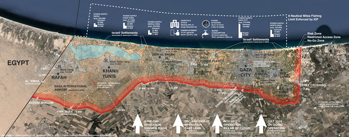
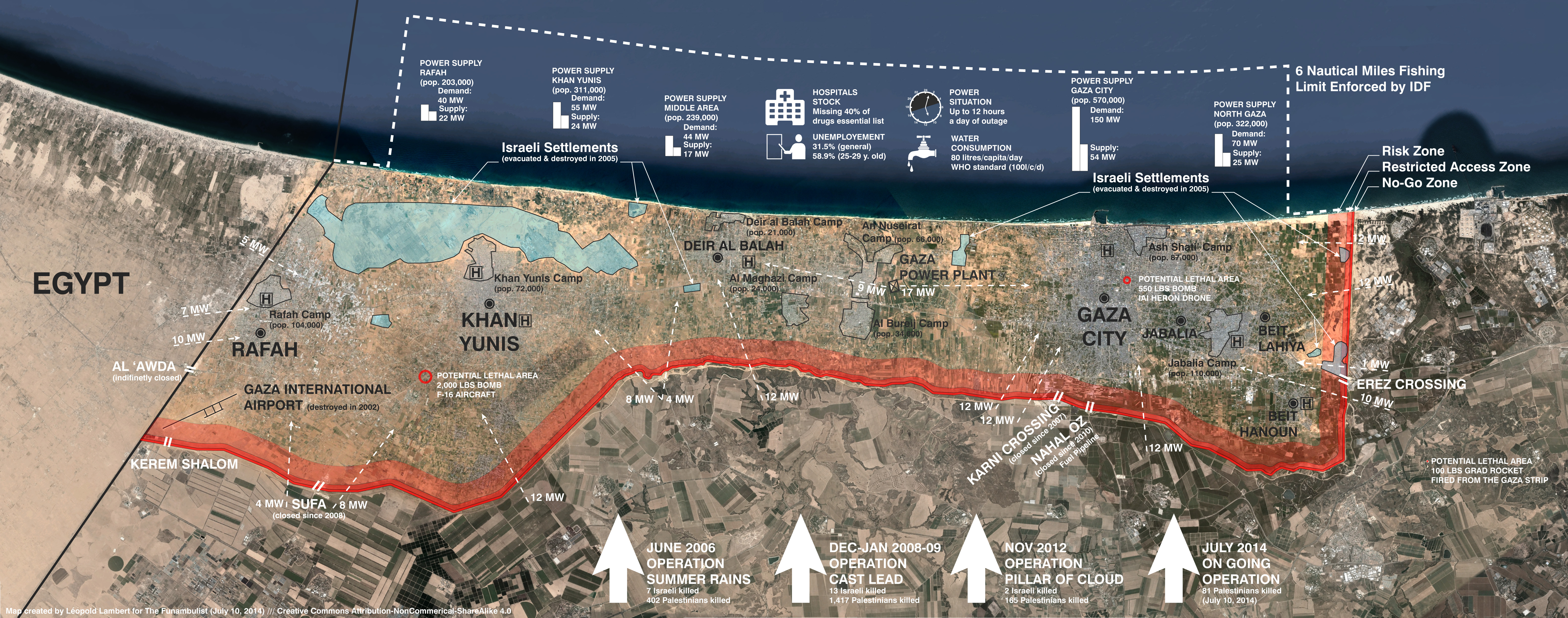
His recent map above – Infrastructural and Militarized Cartography of Gaza – attempts to show at the same level the militaristic and infrastructural aspects of Gaza. This representation strategy is used precisely to demonstrate that a drone attack and the closing of a power supply and/or an access to Gaza both constitute an act of war. Their difference is only in terms of degrees, not in terms of essence. The spectacular military destructions of houses and the lives that they host that currently occur are particular for their extreme, yet localized violence, while the infrastructural violence experienced in daily life (power outages, lack of water, unemployment, restriction of movement, etc.) are admittedly less extreme, yet affect the lives of most people in Gaza.
The infrastructural violence joins the militarized one in the case of the hospital. Many deaths during the bombings would be avoided if Gaza’s hospitals were supplied in essential drugs (they currently miss 40% of them). The fact is that the deadly attack often finds a second wave in the absence of possible care in the hospitals. Inversely, the militarized violence joins the infrastructural one along the Green Line.
The two last types of areas characterized by the map are the camps that host more than 520,000 Palestinian refugees in dense urban fabric, and the former Israeli settlements. The latter were evacuated in 2005 by the Sharon administration, and destroyed by the Israeli army in order to leave no infrastructures beneficial to the Palestinians (some of them had been offered for sale to them at prohibitory prices). The location of these settlements are thus characterized by the tracks of their roads and theirs houses that will probably remain anchored in the ground for decades to come.
No words nor drawings can describe the situation of being attacked from the air without any means for escape: the Egyptian border has been operative on and off since the 2011 revolution and has been closed since November 2013. The only reason that we should keep writing and drawing the conditions of this violence is that the attacks on the Palestinian people (whether in East Jerusalem, in the West Bank, or in Gaza) are themselves organized around words and drawings through governmental policies and military strategies. There is therefore a need to expose them in order to critique them at a political and judiciary level.
See also the map War in the Manhattan Strip by Léopold Lambert comparing Manhattan, NYC with the military apparatuses on and around Gaza as well as the strike records of the day November 2012.

These maps and Léopold Lambert’s concept of a line on a white page that splits two milieus from one another and organizes politically the bodies in space inspired us to start the debate of Tightrope Walking in relation to the tensions and violence escalating summer 2014 in Palestine.
Compilation from the research platform The Funambulist by Léopold Lambert